Copenhagen has become a paragon of urban planning & urban design over the last 70 years. Let’s take a look at some of the tenets of the city’s urban design and why these aspects have come not only to define the way of life in Copenhagen but also serve as a template for what is possible in cities around the world.
 The Five Finger Plan and Public Transportation
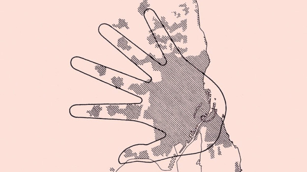
The Five Finger Plan, developed in 1947 through Urban Planning Labratory in collaboration with urban planners Steen Eiler Rasmussen and Christian Erhardt “Peter” Bredsdorff, is an urban development plan that focuses on both metropolitan train lines and the green spaces in between. As you can see from the graphic, the idea is that the train lines (s-tog) spread like fingers on a hand from the “palm” of central Copenhagen. At the time of it’s inception, the Five Finger Plan did not go into Amager, which did not have the infrastructure to support its inclusion. Now, Amager is a much more developed area of Copenhagen and is considered to be the “extra finger.”
The 170 km s-tog lines of the Five Finger Plan, along with an extensive bus system, four lines of waterbuses and a small but efficient metro (2002-2007), make up Copenhagen’s city public transportation system.
![]()
Cars vs. Bicycles
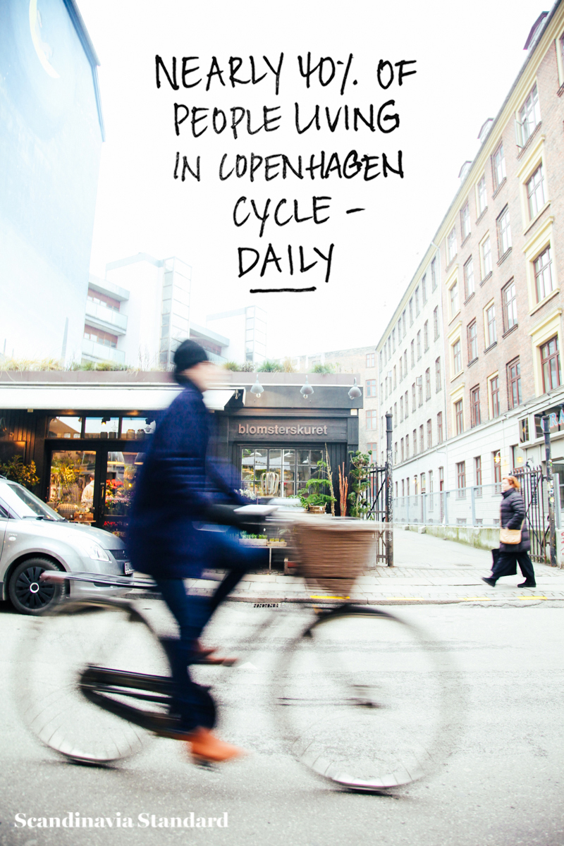
Perhaps you’ve noticed that people like to ride their bicycles in Copenhagen? It’s subtle, but if you look hard I think you’ll see them on the streets. So widespread are cycles and cycle lanes throughout the city that the term “Copenhagenize” has come to meet adding bicycle infrastructure to a city. In fact, when New York City decided to make their city more cycle-friendly, they hired Copenhagen urban designer Jan Gehl.
Nearly 40% of people in Copenhagen cycle daily, with that number expected to continue rising. But it wasn’t always this way in Copenhagen; if you see photos of the 20th century, up until the late 1960’s, there were cars everywhere. Copenhagen isn’t just an example of how cycling infrastructure can work, it’s an example of how fast it can be adopted by a city and its people. Just try imagining CPH without the bikes; can you even do it?

I won’t go into all the benefits of a cycling city, but if you’d like to find out more, Copenhagenize is a good place to start. Check out their sidebar, with a running meter for how many kilometers Copenhageners have cycled on a given day.
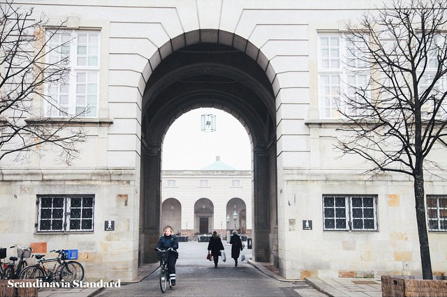
Pedestrian Streets and the walkable city
While cars, public transport and bicycles are all excellent choices for getting from point A to point B, sometimes you need to walk. Maybe you want to stretch your legs, take your dog out or push the pram. Maybe you don’t have a “point B” and just want to enjoy the city itself.
While there are a number of health advantages to walking, there are additional benefits to having a walkable city: economically, shopping areas that are pedestrian-accessible make sense because people can easily get from store to store.
Infrastructure-wise, you don’t need to worry about parking, traffic, and all the problems that must be addressed therein. Aesthetically, it’s simply more beautiful.
Green spaces and playgrounds
Did you know that latest developments in Urban Design suggest that all residences in a city should be no more than 300 meters from a green space? This has lead to an interest in creating small green spaces, rather than larger parks and open areas. While these are often less popular with politicians, the intimate nature of these spaces often means that they are used more frequently by more people than big green spaces. Copenhagen’s urban design has taken on the idea of creating urban gathering spaces all over the city, including the now-world famous Superkilen by Bjarke Ingels Group.

Scandinavia has been on the cutting edge of playground development for years, moving away from conventional structures and using more imagination-based play for children. The beloved Rebskoven (Forest of Ropes) funded by Københavns Kommune (Copenhagen City Council) was created as part of a competition to promote use of public space. Made up of 3,500 lengths of vertical hanging rope, this temporary installation that moves around the country is a magical and surreal playing experience for children and adults alike.
Even permanent playgrounds in Copenhagen, such as the one in the center of recently rebuilt Nørrebroparken, incorporate fun pieces like a sunken-ship structure.
The Future
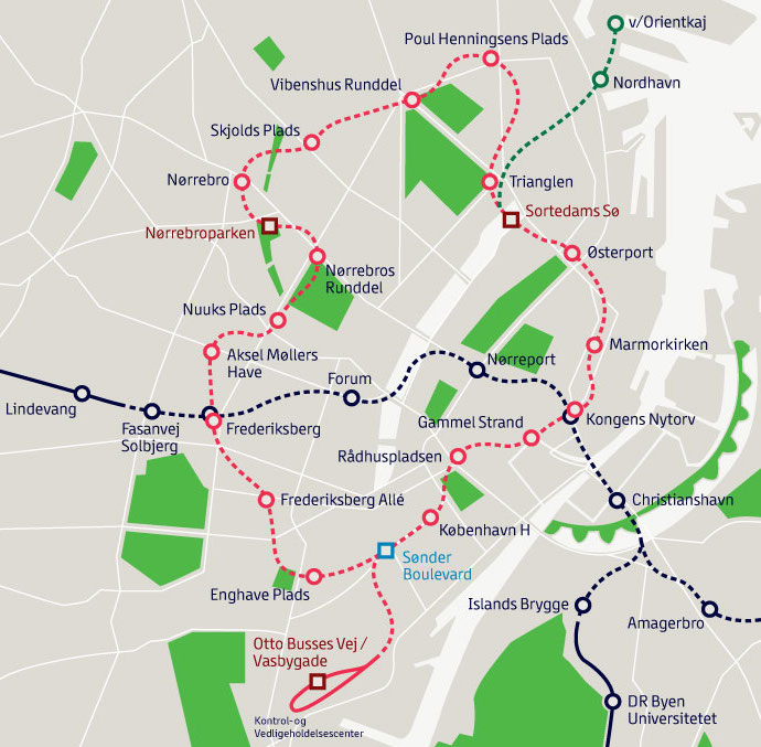
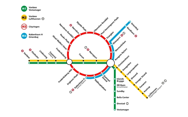
As you may already know, thanks to massive construction sites around the city, Copenhagen is expanding their public transportation system. Specifically, they’re expanding the metro by 17 stops with a circular line (that’s a big jump for a metro that currently only has 22 stops). This is exciting news for those of us living/working outside the center of the city. Nørrebro, Vesterbro and Østerbro in particular will see huge accessibility improvements. In the meantime, the construction sites are being used for art exhibitions and displays – a great way to utilize spaces that would otherwise be eyesores.
This is just the tip of the iceberg in terms of Urban Planning & Urban Design in Copenhagen. We didn’t even get into how this affects public health and the economy. Are you an expert or an enthusiast? Tell us what you think!